Kinco International
Carlson
Narrow Your Results
Main Category
Sub Category
- List View
- Gallery View
| Page of 1 |


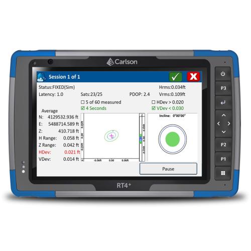
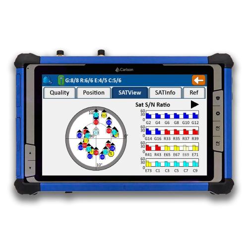
Carlson RT4+ 16GB Ram /256 GB w/SurvPC GPS
Item No. CRL6000.123.010
The Carlson RT4+ is a powerful, rugged tablet data collector designed for demanding field applications in surveying, construction, and GIS.It's built to withstand harsh conditions with an IP68 dustproof and waterproof rating and a MIL-STD-810G shockproof design. The device runs on the full Windows 11 operating system, giving it the power to handle complex software and large files with ease, while its bright 7-inch IllumiView&trade display is highly readable in direct sunlight. Key Features Performance The RT4+ is powered by an Intel N200 processor with 16GB of RAM and a 256GB SSD, providing fast processing and ample storage. This allows it to run not only Carlson's field software but also some of their office applications directly in the field. Connectivity It offers a wide range of connectivity options, including long-range Bluetooth, Wi-Fi 6, and a 4G LTE cellular modem, which is essential for working with GNSS receivers and for receiving RTK corrections via the internet. Durability and Battery Life The RT4+ features a removable, hot-swappable battery that can provide up to 15 hours of continuous use. Its rugged construction and wide operating temperature range (-4°F to 122°F) ensure reliable performance in extreme environments. Software Integration It is specifically designed to work seamlessly with Carlson's SurvPC software, but its open Windows platform also makes it compatible with many other third-party field software solutions and instruments.

Carlson RT5+ US w/ SurvPC GNSS Only
Item No. CRL6001.122.011
The Carlson RT5+ is a ruggedized Windows data collector designed for surveying, stake-out, construction layout and GIS mapping, and is bundled with Carlson SurvPC &ndash the Windows-based data collection program. Optionally, the RT5+ can run SurvPC with Esri OEM for use in the field. With the new 3-year NO-FAULT warranty you&rsquore protected from the unforseen, and with 16GB of RAM and 512 GB of storage, you can collect and analyze your data quicker than ever before.

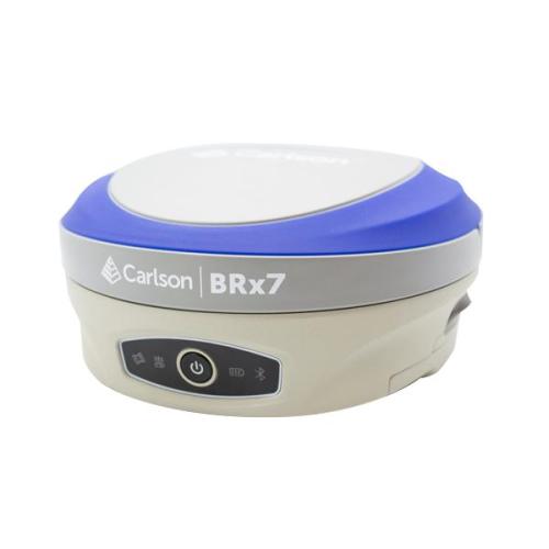
Brx7 Smart Antenna Kit
Item No. CRL8030.020.037
GNSS Rover Only (CRL8030.020.137 Base/Rover package available Click Here to view the product page) The BRx7 GNSS receiver with SurvCE/SurvPC delivers a modern and flexible GNSS RTK product for precision surveys, with an intuitive and familiar application software. The lightweight BRx7 receiver may be used as a Rover, or as a Base to send corrections to RTK UAVs or GNSS Rovers. The BRx7 provides a class-leading 800+ channels, 8gb of memory, tilt compensating ability, and a rugged, compact, IP67-rated housing. Best-in-class RTK performance is provided by the Athena GNSS engine, supporting multi-frequency GPS, GLONASS, BeiDou, Galileo, QZSS, IRNSS, and Atlas L-band capability. The BRx7 has an integrated dual-band UHF transceiver and a Quad-Band GSM modem together with Wi-Fi and Bluetooth. Typical applications include Topographic and Engineering Surveys, Construction, Mapping and GIS.

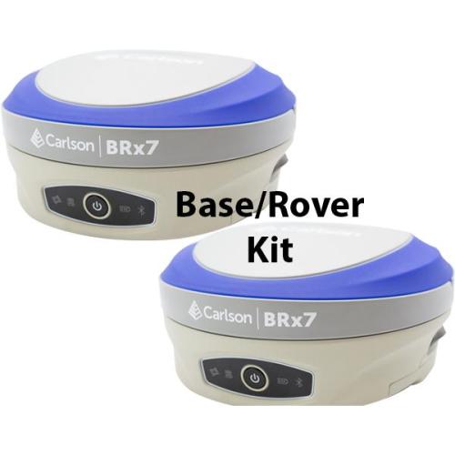
BRX-7 Base & Rover
Item No. CRL8030.020.137
GNSS Base/Rover Receiver Kit (CRL8030.020.037 Antena Kit available Click Here to view the product page) The BRx7 GNSS receiver with SurvCE/SurvPC delivers a modern and flexible GNSS RTK product for precision surveys, with an intuitive and familiar application software. The lightweight BRx7 receiver may be used as a Rover, or as a Base to send corrections to RTK UAVs or GNSS Rovers. The BRx7 provides a class-leading 800+ channels, 8gb of memory, tilt compensating ability, and a rugged, compact, IP67-rated housing. Best-in-class RTK performance is provided by the Athena GNSS engine, supporting multi-frequency GPS, GLONASS, BeiDou, Galileo, QZSS, IRNSS, and Atlas L-band capability. The BRx7 has an integrated dual-band UHF transceiver and a Quad-Band GSM modem together with Wi-Fi and Bluetooth. Typical applications include Topographic and Engineering Surveys, Construction, Mapping and GIS.

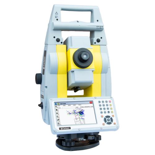
Carlson CRx5 Robotic Station 5" 500 meter range
Item No. CRL8040.033.095
Carlson CRx Series Robotic Total Stations The Carlson CRx series of Robotic Total Stations provides a choice of 1&Prime, 2&Prime, 3&Prime and 5&Prime angular resolutions to match the application requirements. The models are recognizable as the CRx-1, CRx-2, CRx-3 and CRx-5, and all feature the same technologies for a seamless user experience. The instruments are combined with SurvCE or SurvPC on a field computer to access the full range of Carlson survey features for efficiency and automation in a familiar environment. In addition, users have the option for installing SurvCE Basic on board for operation with the instrument only. Customers benefit from technical guidance and support for both the robotic total station and SurvCE or SurvPC from one company. CRx Robotic Total Stations are used with SurvCE or SurvPC in a wide range of applications requiring precise angle and distance measurements such as surveying, engineering and construction. We also have the CRx the Total Stations in 1", 2" and 3" models. Please contact us to see what is best for your needs.

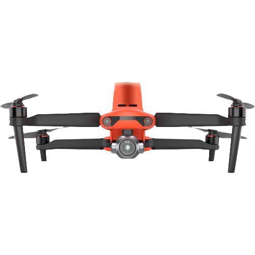
Autel EVO II Pro 6K RTK V3
Item No. CRL8070.070.001
TheEVO II Pro RTKprovides a proven, accurate, durable, and user-friendly,FAA Remote ID CompliantUnmanned Aircraft System (UAS) for numerous applications, including the creation ofsurfaces,point clouds, andorthoimageswithCarlson PhotoCapture, as well asfeature extractionandCAD planswithCarlson Point Cloud. Available in packages with both PhotoCapture and Carlson Point Cloud to take your aerial data to finished deliverables, the EVO II Pro offers up to 36 minutes of flight time, high accuracy positioning with its detachable RTK module, a 20MP camera with 1&Prime sensor, and built-in mission planning for simple setup in the field.


")
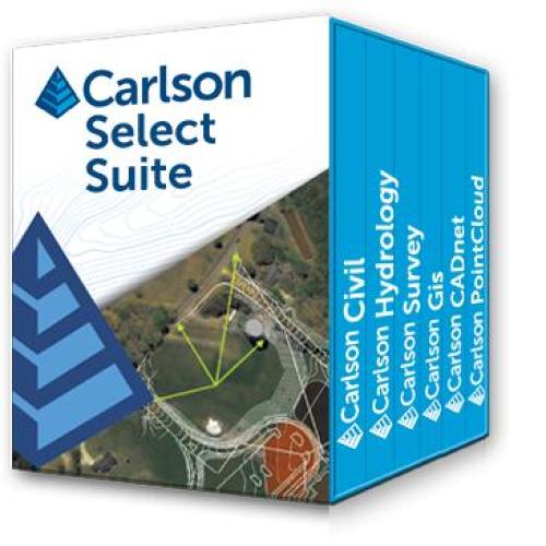
Carlson Select Suite (Civil, Survey, Hydrology, GIS)
Item No. CRL2026.001.001
The Carlson Select Suite isa complete suite of solutions for land development professionals across the disciplines of drafting, land surveying, engineering design and construction estimating.Select Suite users are able to pick and save between two and six modules in order to fit their specific needs and specialization. The eligible modules are Survey, Civil, Hydrology, GIS, CADnet, and Point Cloud Basic. ASK US WHAT YOU CAN DO WITH CARLSON CIVIL SUITE!